2026-09-0500-001266
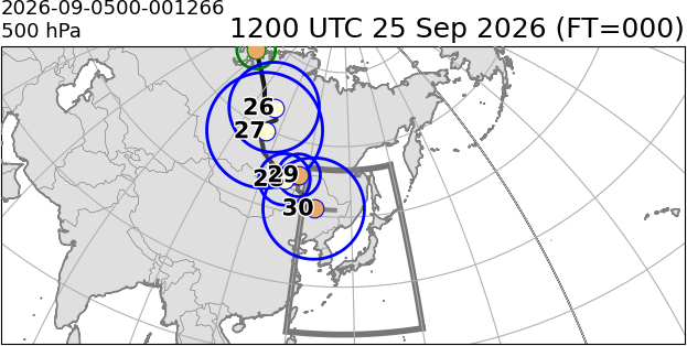

The daily central positions of lows are plotted with reference to the time shown at the top of the image. For a description of each column in the table, please refer to the bottom of this page.
| timestamp | lat | lon | So | ro | Sb | ang | SR | ex |
|---|---|---|---|---|---|---|---|---|
| 12Z 25 Sep | 71.0 | 72.5 | 21.47 | 400 | 40.32 | -1.91 | 1.88 | 0 |
| 18Z 25 Sep | 69.0 | 83.0 | 25.03 | 400 | 35.91 | -2.04 | 1.43 | 0 |
| 00Z 26 Sep | 67.0 | 89.5 | 22.14 | 600 | 28.47 | -2.18 | 1.29 | 1 |
| 06Z 26 Sep | 65.0 | 93.0 | 19.81 | 800 | 24.16 | -2.29 | 1.22 | 1 |
| 12Z 26 Sep | 64.5 | 99.0 | 18.78 | 1000 | 17.86 | -2.36 | 0.95 | 1 |
| 18Z 26 Sep | 63.5 | 100.5 | 19.18 | 1100 | 15.46 | -2.54 | 0.81 | 1 |
| 00Z 27 Sep | 62.5 | 102.0 | 19.17 | 1200 | 13.2 | -2.66 | 0.69 | 1 |
| 06Z 27 Sep | 61.0 | 99.0 | 18.73 | 1300 | 13.65 | -2.83 | 0.73 | 1 |
| 12Z 27 Sep | 59.5 | 100.0 | 17.66 | 1300 | 12.46 | -2.82 | 0.71 | 1 |
| 18Z 27 Sep | 57.5 | 100.0 | 16.99 | 1300 | 12.14 | -2.73 | 0.71 | 1 |
| 00Z 28 Sep | 56.5 | 101.5 | 16.3 | 1300 | 11.01 | -2.64 | 0.68 | 1 |
| 06Z 28 Sep | 55.5 | 102.5 | 15.18 | 1400 | 10.82 | -2.47 | 0.71 | 1 |
| 12Z 28 Sep | 51.5 | 112.5 | 16.77 | 600 | 13.2 | -1.02 | 0.79 | 1 |
| 18Z 28 Sep | 51.0 | 115.5 | 20.59 | 600 | 14.02 | -0.8 | 0.68 | 1 |
| 00Z 29 Sep | 51.5 | 117.5 | 22.14 | 600 | 11.95 | -0.32 | 0.54 | 1 |
| 06Z 29 Sep | 53.0 | 117.0 | 22.12 | 500 | 10.68 | 0.94 | 0.48 | 1 |
| 12Z 29 Sep | 53.0 | 117.0 | 21.79 | 500 | 10.9 | 1.61 | 0.5 | 1 |
| 18Z 29 Sep | 50.0 | 117.5 | 22.59 | 1100 | 6.44 | -1.96 | 0.28 | 1 |
| 00Z 30 Sep | 48.5 | 120.5 | 23.29 | 1200 | 9.27 | -1.67 | 0.4 | 1 |
| 06Z 30 Sep | 47.5 | 123.0 | 22.9 | 1100 | 10.19 | -1.54 | 0.44 | 1 |
| 12Z 30 Sep | 46.5 | 123.5 | 22.62 | 1200 | 12.21 | -1.69 | 0.54 | 1 |
| 18Z 30 Sep | 46.5 | 127.0 | 22.99 | 1100 | 12.68 | -1.6 | 0.55 | 1 |
| 00Z 01 Oct | 46.5 | 130.0 | 22.76 | 1100 | 13.41 | -1.47 | 0.59 | 1 |
Columns
| Name | Unit | Displayed | Description |
|---|---|---|---|
| timestamp | ✓ | datetime | |
| detected_id | Vortex ID that matches the detection rule. | ||
| ID | Vortex ID at the corresponding time. If a split occurs, the detected_id may not match the detected_id. | ||
| lat | deg | ✓ | Latitude |
| lon | deg | ✓ | Longitude |
| val | m | Geopotential height at the center of the vortex | |
| So | m (100 km)-1 | ✓ | Optimal slope |
| ro | km | ✓ | Optimal radius |
| Do | m | Optimal depth | |
| Sb | m (100 km)-1 | ✓ | Intensity of background slope (SBG) |
| ang | rad | ✓ | Direction of SBG |
| m | m (100 km)-1 | Eastward component of SBG | |
| n | m (100 km)-1 | Northward component of SBG | |
| SR | ✓ | Ratio of intensity of background slope (SBG) to optimal slope (So) (SBG/So) | |
| ex | ✓ | COL flag
| |
| Merge | Merge Log
| ||
| Split | Split Log
| ||
| generation | Generation Number Set to 1 at the initial analysis time (FT = 0) and incremented when a different vortex ID is encountered as time is traced backward. |